Back
Station details
The station detail view contains all details about each stations. This includes weather data as well as some calulations
and location and time data.
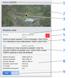
- Name of the station and ICAO code
- Satellite image - the image is shown in a way so that all known runways are fully contained
- Wind arrow, showing the wind direction (arrow in the direction in which the wind blows). Shown at the ARP (Airport Reference Point)
- Date and time of the observation, Age of a METAR report
- Current valid Fligth/weather rule (as configured)
- METAR report, depending on settings (raw or decoded, see 9) the METAR will be shown raw or in decoded, textual form
- TAF report
- Calculations - the calculations are based on the data in the latest METAR report
Cumulus condensation level, 0 °C level and estimated wind gusts are calculated based on rules of thumb known in aviation and
are estimates.
- Switches between raw and decoded METAR view
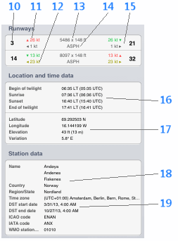
- Runway identification
- Head wind component (green) or tail wind component (red) on this runway
- Cross wind component and direction (arrow, from left or right seen as when landing on this runway), yellow marked if
value exceeds configured crosswind warning threshold
- Runway dimensions (units as configured in Settings)
- Runway surface
- Data for the other runway direction (analog 10-12)
- Sunrise and sunset time, duration of civil twilight for the current day
- Location data and current magnetic variation
- Station data
- Time zone and start and end of daylight savings time in the current year